

Hands-on Learning with Real World Impact
The UAlbany Planning Studio connects second-year Masters in Regional Planning (MRP) students with Capital Region communities to address real planning challenges.
Students develop practical skills in research, analysis and design while providing municipalities and nonprofits with valuable technical assistance and actionable planning recommendations.
Each project culminates in a professional report and public presentation that not only reflects the program’s commitment to collaboration, sustainability and regional impact but also supports data-informed planning and implementation efforts at the local level.
By bridging academic learning and community needs, the UAlbany Planning Studio prepares future planners to create more equitable, resilient and connected places.
Questions? Contact Dr. Catherine T. Lawson at [email protected] or 518-442-4775.
Call for Community Planning Projects
The Department of Geography, Planning, and Sustainability invites Capital Region municipalities and nonprofits to collaborate with our Planning Studio Program.
Submit a project for consideration today! The deadline to propose Fall 2026 projects is Wednesday, April 22, 2026.
community-planning-projects
What communities receive
What communities receive
- Professional-quality research and analysis
- Maps, data and planning documentation
- Policy and implementation recommendations
- Final report and presentation for local decision-makers
How it works
How it works
- Community partners submit project proposals.
- Department faculty review the proposals and select projects that fit the semester’s scope.
- Students work with community partners during the fall semester, from August to December.
- Students deliver a professional report and public presentation summarizing key findings and recommendations to support informed local decision-making in December.
What makes a good project?
What makes a good project?
- Clearly defined but flexible in scope
- Relevant to current planning or development challenges
- Appropriate for a semester-long academic collaboration
- Able to benefit from research, data analysis, mapping or design exploration
Sample project ideas include:
- Neighborhood and focused area plans
- Downtown and corridor studies
- Housing and affordability
- Zoning and land use analysis
- Climate resilience and hazard mitigation strategies
- Transportation and mobility studies
- Environmental and open space planning
- Community engagement
- Data, mapping and geographic information systems (GIS)
Student Learning Outcomes
Through the Planning Studio, students:
- Apply planning theories and methods to real community projects
- Strengthen technical skills in geographic information systems (GIS), data analysis and report writing
- Engage directly with municipalities and stakeholders through public outreach
- Develop collaborative, interdisciplinary problem-solving abilities
- Translate policy and research into actionable planning recommendations
- Gain professional experience in presenting findings to clients and the public
student-learning-outcomes
Past Studio Projects
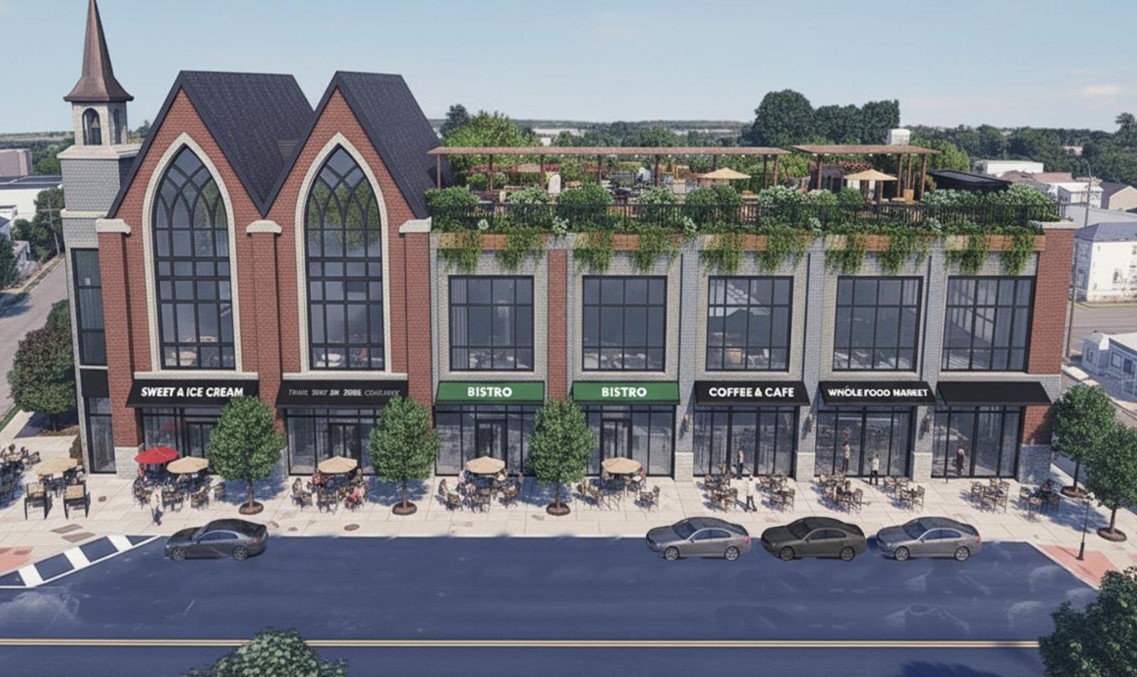
Fall 2025 — Nineteenth Street Revitalization Study for Watervliet

past-studio-projects
About the Nineteenth Street Revitalization Study
About the Nineteenth Street Revitalization Study
Project Goal
The cohort worked with the city of Watervliet on a revitalization strategy for their Nineteenth Street Corridor. The goals shared by the city included:
- Exploring the city’s zoning and climate adaptations
- Creating downtown identity and sense of place
- Assessing potential catalyst sites along the corridor
Project Team
Prepared for: The City of Watervliet, 2 Fifteenth Street, Watervliet, NY 12189
Researched and written by:
- Dalila Oliver
- Fernanda Farche
- Samuel Semon
- Pallav Savaliya
- Geoffrey Cowling
- Michael Shannon
Professor: Kate Maynard, AICP
StoryMap
Fall 2024 — Addressing Tree Equity in Albany: Ecosystem-based Climate Adaptation Strategies for the South End
About Addressing Tree Equity in Albany
About Addressing Tree Equity in Albany
Project Goal
To enhance climate resilience in disadvantaged communities through tree planting and mitigating urban heat island effects.
Project Team
Prepared for:
- Institute for Transformational and Ecosystem-based Climate Adaptation (ITECA), University at Albany
- Radix Ecological Sustainability Center (Albany, New York)
Researched and written by:
- Ted Chesnes
- Raiden Guialdo
- Hanifa Khatibi
- Amir Pooladi Moghadam
- Shan Prevatt
- Erica Schneider
- Melissa Spiegel
- Seymour Yarovoy
Professor: Kate Maynard, AICP
StoryMap
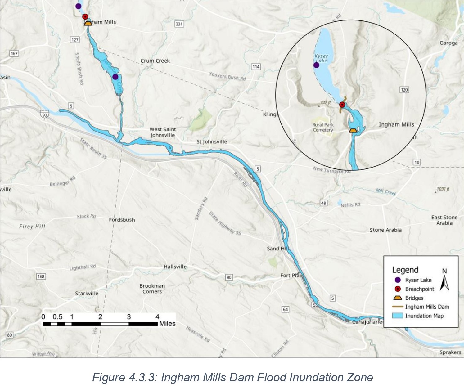
Fall 2023 — Integrating Dam Risks and Failures in State and Local Hazard Mitigation Plans
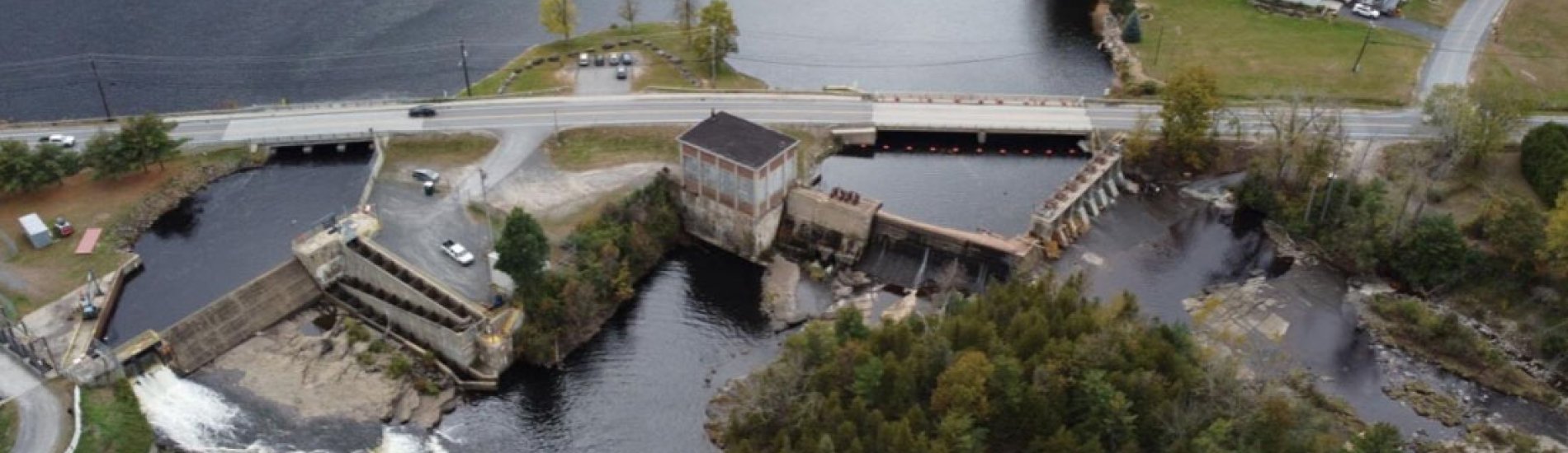
About Integrating Dam Risks and Failures in State and Local Hazard Mitigation Plans
About Integrating Dam Risks and Failures in State and Local Hazard Mitigation Plans
Project Goal
To incorporate strategies and current conditions on specific dams around Fulton and Clinton County in New York State, allowing for the improvement of dams as well as the incorporation of dam improvement within Hazard Mitigation Plans.
Project Team
Prepared for:
- Fulton County Planning Department, New York
- Fulton County Emergency Management Office, New York
- Clinton County Planning Department, New York
Researched and written by:
- Nahid Abbasian
- Likitha Boora
- Patrick Cross
- Ian DeSoucey
- Lance Gundersen
- Melia Hema
- Stephen Hiney
- Mathew Lee
- Vedant Mahajan
- Melissa Marton
- Sergio Ramirez
- Grace Sherburne
Professor: Dr. Jared R. Enriquez
Report
Access the Integrating Dam Risks and Failures in State and Local Hazard Mitigation Plans report.
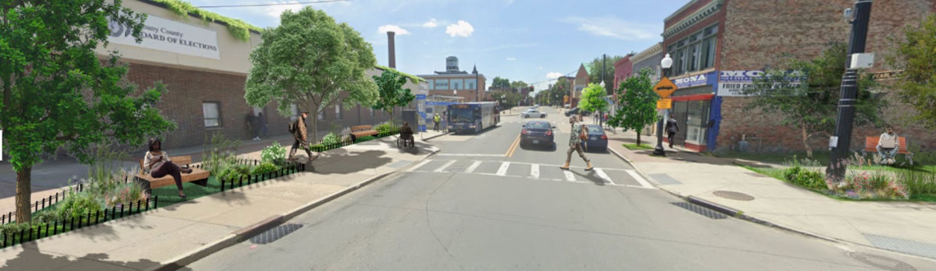
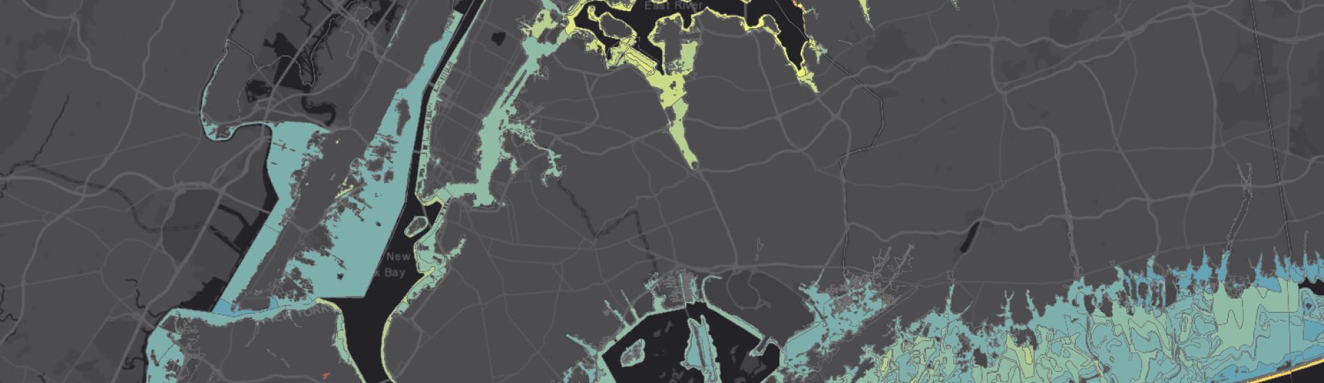
Fall 2022 — Strategies Against Unintended Consequences of Managed Retreat
About the Strategies Against Unintended Consequences of Managed Retreat
About the Strategies Against Unintended Consequences of Managed Retreat
Project Goal
As climate change continues to threaten humanity with the continuation of rising sea levels in coastal areas and flooding along the inland waterfronts, people and communities will need to relocate from spaces that are no longer tenable for permanent human habitation.
It is vital that planners and government officials share in the collective responsibility of reckoning with the challenges created by the relocation from those vulnerable spaces. Some of those challenges are clear; danger to human life and loss of wealth as properties become uninhabitable to name just a few.
This project focused primarily on the less apparent potential negative outcomes and problems officials are likely to need to address as sea levels rise and flooding become more common.
Project Team
Prepared for:
- Dr. Jared R. Enriquez, Department of Geography, Planning, and Sustainability, UAlbany
- Dr. Catherine T. Lawson, Department of Geography, Planning, and Sustainability, UAlbany
Researched and written by:
- Jack Connelly
- Steven Golding
- Julian Hicks
- Mohammed Ibrahim
- Cindy Isidoro
- Stephen Napier
- Mansi Parmar
- Destiny Riviello
- Will Singleton
Professors:
- Dr. Jared R. Enriquez
- Dr. Catherine T. Lawson
Report & StoryMap
Access the Strategies Against Unintended Consequences of Managed Retreat report.
Access the Strategies Against Unintended Consequences of Managed Retreat StoryMap.
Fall 2021 — Mitigating Vacancy in Arbor Hill & West Hill: An Asset-Based Approach

About Mitigating Vacancy in Arbor Hill & West Hill
About Mitigating Vacancy in Arbor Hill & West Hill
Project Goal
The Fall 2021 Planning Studio focused on the problem of vacancy in the Arbor Hill and West Hill communities in the city of Albany.
In partnership with the Arbor Hill Development Corporation, the Studio’s overarching goals included strengthening and expanding our collaborative networks with racially diverse communities to promote racial justice and highlight potential strategies for preventing and mitigating vacancy.
The findings of the report provide a framework for future development available through a combination of existing assets and the ability to transform vacant areas.
Project Team
Prepared for: Arbor Hill Development Corporation, 241 Clinton Avenue, Albany, NY 12210
Researched and written by:
- Sondos Assallami
- Katherine Corini
- Derek Crossman
- Amanda Diaz
- Austin Erickson
- Samuel Haas
- Alyssa Losee
- Emily Loughlin
- Dominic Maiello
- Jon Midler
- Tori Roberts
- Christopher Seeger
- Nikolai Tubbs
- Megan Zimba
Professors:
- Dr. Jared R. Enriquez
- Dr. Catherine T. Lawson
Report
Access the Mitigating Vacancy in Arbor Hill & West Hill report.
Fall 2020 — Delaware County Hazard Mitigation Plan Update: Mitigation and Adaption Opportunities
About the Delaware County Hazard Mitigation Plan Update
About the Delaware County Hazard Mitigation Plan Update
Project Goal
Like many communities in the United States, Delaware County, New York, is committed to reducing the impacts of severe and frequent disaster risks for its residents.
Integrating mitigation and adaptation solutions within community planning efforts can reduce exposure to the losses of life and property posed by natural hazards and climate change. The best time to implement mitigation measures is before disaster strikes.
This project sought to identify mitigation and adaptation solutions appropriate for supplementing Delaware County’s 2020 Hazard Mitigation Plan Update.
FEMA requires that jurisdictions updating their Hazard Mitigation Plans identify how stakeholders were invited to participate in the update process. Stakeholder engagement included partners in academia.
Project Team
Prepared for: Delaware County Planning Department, Delhi, New York
Researched and written by:
- Andris Blumbergs
- Snehal Chavan
- Nora Culhane Friedel
- John Donnelly
- Aleesha Fiddemon
- Daniel Madigan
- Ikenna Mbadiwe
- Jesse McCaughey
- Mark Meigher
- Gopika Muddappa
- Michael Oleksyn
- Prachi Patel
- Ben Turin
Professors:
- Dr. Jared R. Enriquez
- Dr. Catherine T. Lawson
StoryMap
Access the Delaware County Hazard Mitigation Plan Update report.
Fall 2019 to Fall 1993
About the projects undertaken Fall 2019 to Fall 1993
About the projects undertaken Fall 2019 to Fall 1993
Fall 2019
Fall 2018
Information for Natural Resource Inventory for City of Saratoga Springs, New York
Spring 2018
Report: Public Engagement for the Village of Menands Comprehensive Plan
Opportunity Analysis for the Village of Menands Comprehensive Plan
Report on Community Survey Analysis for Village of Menands Comprehensive Plan
Report on Open House Public Input for the Village of Menands Comprehensive Plan
Fall 2017
Community Profile for the Village of Menands, New York (Presentation)
Community Profile for the Village of Menands, New York (Report)
Review of Past Plans for the Village of Menands, New York (Meeting Notes)
Review of Past Plans for the Village of Menands, New York (Report)
Plan Assessment Matrix for the Village of Menands, New York
Fall 2016
City of Cohoes Land Use and Zoning Recommendations
Fall 2015
Beyond Central: A Community Moving Forward
Fall 2014
New York State Canal Recreationway Plan: Opportunity Analysis
New York State Canal Recreationway Plan: Public Meeting
New York State Canal Recreationway Plan: Stakeholder Interviews
Palenville, New York, Greeneways Plan
Fall 2012
Rezoning Albany: A Pilot Assessment of the South End Neighborhood (Executive Report)
Rezoning Albany: A Pilot Assessment of the South End Neighborhood (Final Report)
Fall 2011
Clinton Square / Downtown Albany: Where Albany Comes Together
Fall 2010
Kinderhook-Stuyvesant-Stockport Inter-municipal Trail Feasibility Study
Sheridan Hollow: Steps Forward, Making Redevelopment Work
Fall 2009
Arbor Hill Partnership Feasibility Study
Open Space, Community Resources & Public Arts: Integrating Arbor Hill
Fall 2008
Arbor Hill Neighborhood Public Arts And Online Community Resources For Community Pride
Arbor Hill Neighborhood Public Parks & Open Spaces
Fall 2007
Mid-City University District: A Partnership for Positive Change
Fall 2006
Golden Grid: Pedestrian And Bicycle Plan
Mohawk River Public Access Plan
Fall 2005
Destination Fort Edwards: A Strategy for Community and Economic Development
The Purple Path: The Multiple Use Path for the University at Albany Community
Fall 2004
Canajoharie Crossroads: Our Heritage, Our Future
The Art of Planning: A Healthy Infrastructure Plan for Sugar Loaf, New York
Fall 2003
Traffic Calming: Old Benningtion, Vermont
Commercial Corridor And Neighborhood Study For Van Vranken Avenue And The Goose Hill Neighborhood
Fall 2002
The Problems and Potential of Vacant Buildings: A Survey of Vacant Structures in Albany, New York
Fall 2001
Planning & Design Recommendations for the West Side Neighborhood, Saratoga Springs, New York
Fall 1999
Planning Recommendations for the Central Areas of the City of Rensselaer
Fall 1998
Schoharie Main Street and Gateways: Realizing the Vision
Community Economic Development Plan for the Schenectady Enterprise Community, Schenectady, New York
Fall 1997
Champlain Canal Trail Scenic Byway: Preliminary Study
Fall 1996
Fall 1995
North Central Troy: GIS Mapping & Planning Alternatives