


New York State Mesonet Collaborates on Maine Statewide Weather Network
By Mike Nolan
ALBANY, N.Y. (March 6, 2026) — The University of Maine is launching a statewide weather monitoring network through collaboration with the New York State Mesonet at the University at Albany's Atmospheric Sciences Research Center.
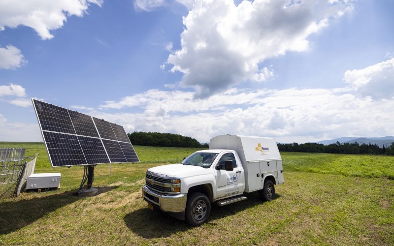
University of Maine Cooperative Extension recently installed an advanced weather station in Orono, the third in what will become the Maine Mesonet, a network of 26 research-grade weather stations designed to provide localized weather data for agriculture and environmental monitoring.
The Maine Mesonet network’s data will be collected, processed and quality-controlled by the New York State Mesonet team in Albany.
The NYS Mesonet is the most advanced and largest statewide weather observation network in the nation, featuring 127 standard weather stations, spaced an average of 17 miles apart across the state. UAlbany designed, installed and has operated the network for the last 10 years.
Each NYS Mesonet site is equipped with automated sensors that measure various weather variables in real time, as well as a camera that photographs current conditions. The data is collected every five minutes, feeding weather prediction models and decision-support tools for users across New York.

“We’re excited to launch this first-of-its-kind partnership between two statewide mesonet networks,” said NYS Mesonet Director June Wang. “As extreme weather events become more frequent and severe, the demand for real-time weather data is growing rapidly. Our team is proud to demonstrate how we can make sharing data easier, more efficient and more valuable for end users. We look forward to extending these services to additional weather networks in the future.”
Leaders from the Maine Mesonet began collaborating with the NYS Mesonet in early 2025 to learn from their experience in network design, operations and data management. The collaboration was formalized later that year, with the UAlbany team now managing Maine’s mesonet data.
"This project marks the first time that the full data processing system of the NYS Mesonet has been used to process data for another Mesonet,” said Nathan Bain, senior software engineer at the New York State Mesonet. “Every five minutes, our system retrieves data from each Maine Mesonet station onto our system, performs automated quality control checks, applies necessary coefficients and archives and disseminates this information in under a minute. This demonstrates the flexibility of our system and its ability to adapt to other observing platforms around the nation."
As droughts, downpours, extreme heat and spring frosts become more common, Maine farmers will be able to use the new mesonet data to make more informed decisions for planting, irrigation and crop protection.
Soil-moisture data from the network will also be used by the Maine Drought Task Force and the U.S. Drought Monitor. The information will additionally be distributed to national companies that use weather data to predict larger trends in weather and storms, resulting in more accurate models.
“Maine is seeing warmer temperatures, and in the past decade the state has also been variously impacted by drought,” said Maine State Climatologist Sean Birkel, who will oversee the Maine Mesonet. “A Mesonet gives us high-resolution, real-time observations to track these shifts in the field throughout each season. Additional observations can improve local forecasts, making them more useful to farmers. These observations will also help statewide drought monitoring and planning.”
The Maine Mesonet project is installing stations across all 16 counties, prioritizing agricultural hubs. Three stations are planned each for Washington (wild blueberry) and Aroostook (potato) counties and other areas of high agricultural production, especially where gaps in existing weather data exist.
Detailed weather and environmental data from the network will be accessible on the Maine Climate Office website.