

The Fight for Clean Water and Flood Mitigation

Sustainable water resources management, which aims to solve or avoid water quantity and quality issues, is essential for the sustainability of the global economy, society and environment. The sustainability of water resources is significantly impacted by population growth, climate change, and land use/land cover change. Issues and challenges of sustainable water resources management in both urban and agricultural contexts need to be addressed.
Assistant Professor Yaoze Liu’s Hydrology and Water Quality Lab team is working to address water quality and quantity issues, including some that pose particular health and safety risks in New York State.
Local and Regional Issues and Needs
(1) Harmful Algal Blooms
Harmful Algal Blooms (HABs), which are overgrowths of algae that produce toxins and severely impact human and aquatic ecosystems, are a major environmental problem in New York, as well as other parts of the United States. HABs usually occur in nutrient-rich (nitrogen and phosphorus) slow-moving waters with high temperature. Nutrients in water bodies released by human activities -- in both agricultural and urban areas -- cause more severe and frequent blooms.
The records of the New York State Department of Environmental Conservation show that HABs occurred in a large number of waterbodies in New York State during the past 7 years. New Yorkers may also face a greater risk for exposure to HABs due to current water treatment infrastructure.
(2) Flooding and Combined Sewer Overflows
Urban development generally leads to the higher portions of impervious surfaces, a major factor that increases flood risk. Combined sewer systems are commonly used to collect and deliver stormwater runoff, domestic sewage, and industrial wastewater. Then, the polluted water would be treated by treatment plants. However, when capacities of combined sewer systems are overloaded due to snowmelt or stormwater runoff, combined sewer overflows (CSOs) occur, potentially polluting receiving water. Combined sewer systems can be found throughout New York State, with about 800 CSO outfalls in the state, causing water quality impairments during wet weather. Floods, which can be a serious problem in many parts of New York State, account for more than $1 billion in property losses in the United States each year.
(3) Needs
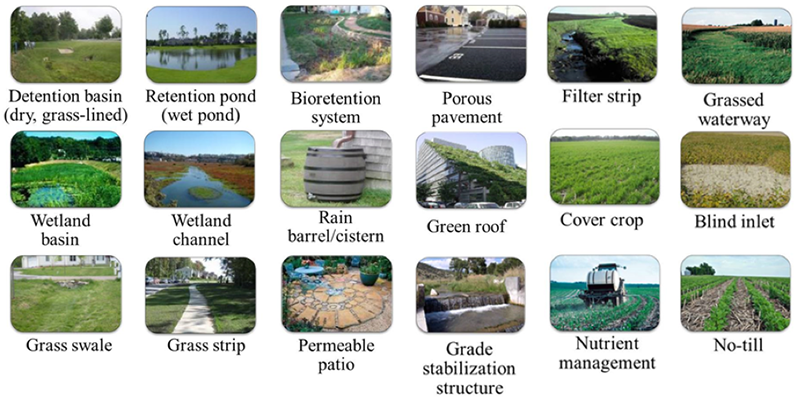
Agricultural best management practices (BMPs, see Figure 1), such as blind inlets, wetlands, grade stabilization structures, filter strips, grassed waterways, cover crops, no-till, and nutrient management, are popular approaches for reducing nutrients delivered to waterbodies, resulting in decreased HABs. Urban BMPs, such as dry ponds, wet ponds, wetlands, porous pavements, permeable patios, wetland channels, rain barrels/cisterns, grass swales, grass strips, green roofs, and rain gardens, can help reduce flooding, CSOs, and HABs caused by excess nutrients.
Although the observed performance of urban and agricultural BMPs was reported in numerous studies, spatial-temporal data are limited due to constraints of resources and measurement techniques. In addition, results from these studies could not be directly used in the analysis of planning scenarios to demonstrate the effectiveness of the practices. Therefore, hydrologic/water quality models that can simulate BMPs are needed to provide such capabilities. The planning strategies for implementing BMPs at watershed scales incorporate conflicts among environmental concerns and economic considerations. The possible types, locations, and quantities to apply BMPs at a watershed scale are numerous because of the complexity of land uses, soil properties, and site characteristics of the watershed. Therefore, it is not feasible to identify the performances of all potential combinations of BMP scenarios at watershed scales.
Since watershed management projects usually have limited budgets or an explicit environmental impact goal, decision support tools are needed for decision makers to identify problems and create cost-effective urban and agricultural BMP implementation strategies by comparing tradeoffs among environmental impacts and economic considerations.
Current and Future Research

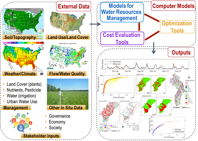
To help decision makers create cost-effective BMP implementation strategies, the framework for Decision Support Systems (DSS) associated with water resources sustainability (Figure 2) is used by the research group to develop BMP decision support systems. The external data needed for the decision support systems include soil, topography, land use, land cover, weather or climate, flow, water quality, management activities in the area, other in situ data, and stakeholder inputs (governance, economy, and society). Then, these external data are used to set up and calibrate/validate the water resources management models. Water resources management models are used to estimate the efficiencies of BMPs, while Cost Evaluation Tools are used to calculate the costs of implementing BMPs. Spatial optimization algorithms, which are multi-objective methods that have tradeoff solutions, are used in the optimization tools. With efficiencies and costs of BMP implementation scenarios as the objective functions of the optimization tools, BMP decision support systems can be created by linking optimization tools with water resources management models and Cost Evaluation Tools.
Liu and his team are working to develop optimization-based decision support systems to obtain cost-effective strategies to address HABs, flooding, and other water quality/quantity problems. This is done by analyzing places where agricultural and urban best management practices (BMPs) have been implemented, then using the decision support systems to see where additional practices should be applied to obtain the greatest positive impacts with the lowest costs.
(1) Agricultural BMP Decision Support System
An agricultural BMP decision support system, which combines multi-objective optimization algorithms, SWAT (Soil and Water Assessment Tool), agricultural BMP Cost Evaluation Tool, and a two-level computational efficient framework, was created to optimally apply agricultural BMPs at watershed scales. The agricultural BMP decision support system was demonstrated in an agricultural watershed with a group of outputs shown in Figure 2. The initial implementation of BMPs with low expenditures greatly reduced pollutant loadings; beyond certain levels of pollutant reductions, additional expenditures resulted in less significant reductions in pollutant loadings. Compared to optimization for the entire watershed, optimization in critical areas can greatly reduce computational time and obtain similar optimization results for initial reductions in pollutant loadings, which were 10% for Dissolved Reactive Phosphorus (DRP) and 38% for Total Phosphorus (TP); however, for greater reductions in pollutant loadings, critical area optimization was less cost-effective. With the target of simultaneously reducing March-July DRP/TP losses by 40%, the optimized scenario that reduced DRP losses by 40% was found to reduce 51.1% of TP; however, the optimized scenario that reduced TP losses by 40% can only decrease 11.3% of DRP.
To benefit local and regional communities, ongoing and future research is conducted to improve the agricultural BMP decision support system focusing on the needs of New York State: (1) improve SWAT in simulating the effectiveness of agricultural BMPs commonly used by New York State in reducing nutrients and sediment from agricultural sources; (2) improve the agricultural BMP Cost Evaluation Tool in evaluating BMP costs based on New York State data; and (3) improve the optimization algorithms used in the optimization tool. The improved agricultural BMP decision support system will be able to help stakeholders in New York State obtain optimal types, quantities, and spatial locations of agricultural BMPs that can maximize reductions in pollutant loadings/HABs with the lowest BMP costs.
(2) Urban BMP Decision Support System
To benefit local and regional communities, ongoing and future research is conducted to create an urban BMP decision support system: (1) improve the SWAT model by representing the hydrological processes and water quality improvement functions of additional commonly used urban BMPs and enhancing the representations of urban BMPs currently in the model; (2) develop an urban BMP Cost Evaluation Tool to evaluate the costs of urban BMPs based on data in New York State; and (3) develop an urban BMP decision support system that uses spatial optimization methods to obtain the optimal types, quantities, and spatial locations of urban BMPs, which can maximize the reductions of runoff volume, peak runoff, nutrients, and sediment with minimum cost. The urban BMP decision support system will be able to help decision makers create cost-effective urban BMP implementation plans that can reduce flooding, CSOs, and HABs.
Liu’s research holds the potential to positively impact local and regional communities throughout New York that are currently at risk from harmful algal blooms, flooding, and other water quality/quantity problems.
Dr. Yaoze Liu is an Assistant Professor in the Department of Environmental and Sustainable Engineering at University at Albany and Director of the Hydrology and Water Quality Lab. Before joining University at Albany in 2018, he was a post-doctoral researcher at Purdue University.