Ask Geoff
By Geoff Williams, University Archivist
The Uptown Campus: From Crossroads to Construction Site
For centuries, the property where UAlbany’s uptown campus is situated has been surrounded and cut through by east-west transportation routes and various streams. In the 1800s and early 1900s, the property’s south side was drained by a stream rising from a kuyl (Old Dutch for “pit”), or, depending on the authority, possibly the east branch of the Kromme (Old Dutch for “crooked”) Kill (Dutch for “stream”) or the Hunger Kill under the Great Western Turnpike, which is Western Avenue today. A branch of the Patroon Creek, which flowed under – and sometimes over – Washington Avenue drained the north side.
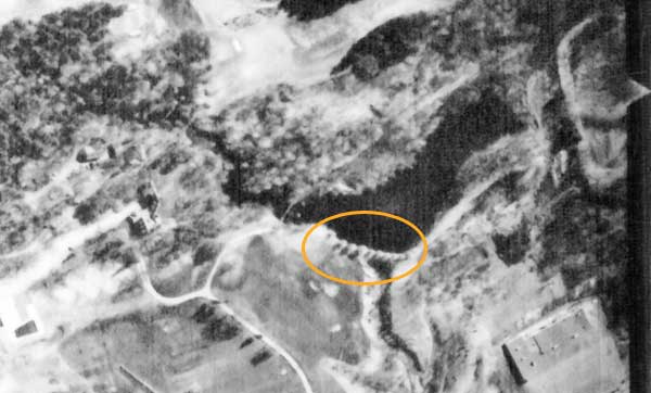
This 1962 photo from the University Archives shows the kuyl at the Albany Country Club (ACC). The wooden dam is circled.
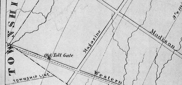
Long ago, Native Americans portaged canoes from the Mohawk River, where Schenectady is now, to the Hudson at what became Albany, avoiding the falls at Cohoes. This path offered refreshment from the spring-fed waters of the kuyl, or Hunger Kill (supposedly the best water in the region), making the location an ideal resting point for travelers. Not surprisingly, the King’s Highway, a two-rut wagon track between Albany and Schenectady, followed the Native American trail across what would become the uptown campus. Old Roads Running through the Albany Country Club Property, a 1940s map William Efner based on a 1760s map of the area, shows successive taverns being established beside the kuyl (Efner spelled it “Knil”) on the King’s Highway, just north of UAlbany’s Campus (Indian) Pond. According to Efner’s map, Ritches Tavern, located 5 miles from downtown Albany and also known as Five Mile Tavern, existed by 1760. Within 20 years, McKown’s Tavern rose on the same site, near where Indian Quad now stands. When the Western Turnpike was established, diverting traffic from the King’s Highway, McKown built a second tavern south of the intersection of Fuller Road and Western Avenue in what is now McKownville.
 |
 |
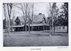
The ACC is seen, above left, in this 1910 Albany Country Club Constitution picture, courtesy New York State Library.
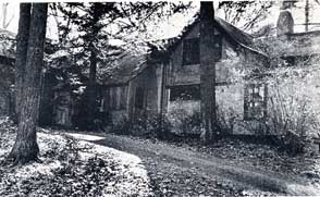
Above right, Chapel House was once located in the old hunting lodge pictured in this University Archives photo. The building was destroyed by fire in 1985, and a new Chapel House was built nearby.
In 1889, a private group purchased the old roadhouse located approximately where Indian Quad is, intending to transform the parcel into a fox-hunting club. The plan proved unpopular; the club held Saturday afternoon teas – and apparently little else. Membership declined, and the group reorganized in 1893 as the Albany Country Club (ACC). A year later, the Knowlton Estate, a large Western Avenue property, was added to the tavern parcel, and a clubhouse and golf course were built. The new country club quickly won the support of prominent Albanians, including the Van Rensselaer, Pruyn, Sage and Lansing families. The popular venue also offered tennis courts, and later, swimming and skating on the kuyl/kill, which was dammed by a 300-foot earthen-and-wooden dam in exactly the location where Indian Pond is situated today.
 |
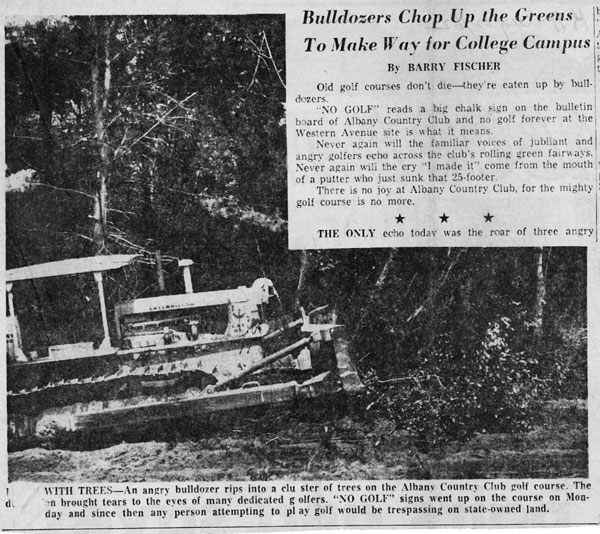 |
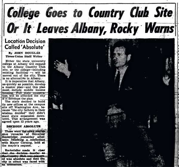
| Clippings from the Sept. 20, 1960, Times Union, above left, and the Aug. 22, 1962, Knickerbocker Press, above right, detail some of the challenges that arose as the country club made way for UAlbany's uptown campus. The clippings are from the Times Union and University Archives, respectively. | |
On the high hillock to the west, directly across from what is today SEFCU Arena, was the Billy Barnes Hunting Lodge. Built in 1905, the lodge was owned by the chairman of the Albany Republican Machine, which controlled Albany until the O’Connell Democrats took over in 1920. Barnes was a grandson of Thurlow Weed, a state and national leader of the Whig Party and a founder of the Republican Party. The Albany Council of Churches purchased the lodge in the late 1960s; until it burned in 1985, the building housed a chapel house for the new campus. It was replaced by the current Chapel House at the bottom of the hill.
Acquiring the property for the newly designated SUNY University Center at Albany was difficult. Even though the ACC sold off parcels of its property along Western Avenue, country club members, at least publicly, were reluctant to sell. At one point, then-Gov. Nelson A. Rockefeller threatened to move the new Edward Durell Stone-designed campus to the Helderbergs or Saratoga Springs, depriving the City of Albany of revenue from the new University. Eventually, the parties arrived at a fair price, but the troubles continued: As bulldozers reshaped the land, ACC members continued to play their course. To prevent being hit by errant golf balls, construction crews cut down trees and piled them in front of the greens. More havoc ensued in March 1963, when the old country club pond retaining wall collapsed. Fifteen million gallons of water, huge chunks of ice and trees cascaded across Western Avenue into homes and businesses – stranding one homeowner’s car in a tree blocks away. The dam was repaired and reinforced, and the pond remained.
Within a year (Fall 1964), students would begin moving into Dutch Quad, and, by 1966, the first courses would be offered on the uptown campus. Shortly thereafter, University at Albany students and faculty began walking the old trail beside the Hunger Kill.
- UAlbany Magazine
Fall 2012 - Cover Story
- Features
- Departments
- The Carillon
- Past Issues