
UAlbany Conference Spotlights Role of Mobile Technology to Identify Location and Rates of Disease, Yield Access-to-Care Improvements
8th Annual GIS Day Highlights Public’s Role in Health Data Collection Efforts
Albany, N.Y. (April 23, 2012) -- The use of Public Participatory Geographic Information Science (PPGIS) to identify location and rates of disease as a means to improve access-to-care in our region is the focus of the University at Albany School of Public Health’s 8th Annual GIS Day: Public Participatory GIS on April 24. This science involves the collection of information, photos and geographic locations using mobile devices such as smartphones and tablets that can easily be added to maps.
 |
|
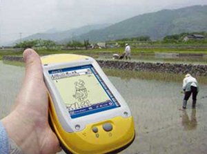
GIS mobile technology can help public health officials assess flood damage following a storm.
|
GIS has been utilized for analyzing the health of populations, including rates of disease in particular areas, access to health care by location, and reaching difficult-to-access populations for vaccinations and immunizations. Mobile devices offer another vehicle to enhance this data by collecting locational information, sources of healthy foods, emissions of environmental pollutants, infectious diseases and needs assessments in times of emergencies.
Discussions will focus on the benefits and the risks associated with these new technologies. They show promise in providing time-sensitive, fluid data from a broad pool of subjects using sophisticated yet easy-to-use data collection tools used in public health and emergency response.
The conference is designed to advance understanding of GIS and PPGIS among students, county and state public health practitioners and educators, from nationally recognized experts in the field of GIS and public health. The conference precedes a day-long workshop on April 25.
The speakers include:
- Timothy L. Hawthorne, assistant professor of geography in the Department of Geosciences and an Affiliated Faculty with the Partnership for Urban Health Research at Georgia State University, whose broad research and teaching interests are in community geography, Geographic Information Systems, Participatory Geographic Information Systems, mapping, urban geography, public health and service learning.
- David Scales, medical sociologist and research fellow with HealthMap. Scales currently leads a project developing an online tool for users to do geographically based risk analysis incorporating information on demography, migration and infectious diseases. His research focuses on examining the relationship between new demographic indicators and infectious disease among foreign-born populations in the U.S. as well as analyzing HealthMap data to predict periods of higher and lower reliability.
- Christopher Goranson, is a nationally recognized expert in the field of GIS and director of the Parsons Institute for Information Mapping at the New School. The Parsons Institute’s mission is to advance the field of “Knowledge Visualization,” or how we collect, interact and visualize information on maps. Goranson is also lecturer at both Hunter College and the Mount Sinai School of Medicine in New York City.
- Wansoo Im, president and founder of VERTICES, LLC. Im is also the founder of the Center for Community Mapping, a non-profit organization. Im specializes in developing decision support systems using a public participatory approach and interactive web-based geographical information systems (GIS). He is an assistant professor at Meharry Medical College, and an adjunct faculty member at Rutgers, The State University of New Jersey.
- Tara Salerno, an environmental review specialist with the New York Natural Heritage Program (NYNHP). Salerno’s primary role is to screen projects for potential impacts to rare species and significant natural communities, as well as provide NYNHP data to partner organizations and agencies.
This workshop is supported by the New York State Department of Health and grants from the Centers for Disease Control Environmental Tracking and the Agency for Toxic Substances and Disease Registry Brownfield Programs.
![]() For more news, subscribe to UAlbany's RSS headline feeds
For more news, subscribe to UAlbany's RSS headline feeds
A comprehensive public research university, the University at Albany-SUNY offers more than 120 undergraduate majors and minors and 125 master's, doctoral and graduate certificate programs. UAlbany is a leader among all New York State colleges and universities in such diverse fields as atmospheric and environmental sciences, business, education, public health,health sciences, criminal justice, emergency preparedness, engineering and applied sciences, informatics, public administration, social welfare and sociology, taught by an extensive roster of faculty experts. It also offers expanded academic and research opportunities for students through an affiliation with Albany Law School. With a curriculum enhanced by 600 study-abroad opportunities, UAlbany launches great careers.
