Albany Rural Cemetery Exporer User Tutorial
Welcome to the ARCE tutorial for first-time users! The information herin is assembled to provide orientation of this location-based application to view and query data, and navigate in the Albany Rural Cemetery. This map application may be accessed using any device including desktop computers, mobile phones or tablet with internet.
The access to this location-based application is provided on the page of Explore, where access to this tutorial is provided. Once you’ve oriented yourself, you can easily go back to the Explore page to start investigating all our themed tours.
Entering into the application the user is greeted with the full cemetery view, with all tour themes visible.


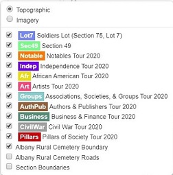
The layer list in the maps upper right-hand corner controls the themes and their visibility on the map. Opening the layer list by mouse click displays the tour themes, differentiated by its symbol color on the map. You can turn on or off layers at your preference. Unchecking a layer only removes it from display. You can check the box again to remap the theme back on your screen. At the top of the list, the user can select their preferred background, being topographic which is the default, or full color satellite image.
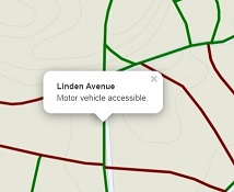
The roads layer differentiates travel by motor vehicle (green) or pedestrians where motor vehicles are prohibited (maroon). Clicking on any road affirms its travel status. Clicking on a motor vehicle road also provides its name.
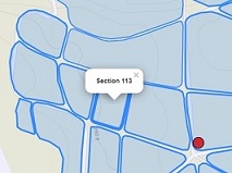
If the cemetery sections layer is displayed, clicking any section will display the identification number.
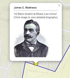
Clicking any point from a tour theme, returns a popup displaying the individuals name, a portrait if available, and highlights one of their life accomplishments. Clicking on the popups image, irrespective of it being a portrait or default “No Image”, returns a biography of their life including text, pictures or other media.

In the lower left corner of the map is the scale bar which changes as the user zooms in/out.
In the maps upper left corner are a series of control icons. A mouseover of any icon responds with its purpose.

Zoom in/Zoom out. Alternatively, the scroll on the desktops mouse will also perform this function. Dragging with the mouse performs the Pan function.

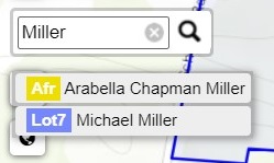

Search. Allows a search of the tours databases for a specific name. Click the icon and type in a name. Popups will display a match of the name as being included in a tour theme. Selecting the popup for Arabella Chapman Miller zooms to the location and displays her name and portrait image. Tour themes need to be turned on for display in order for the search tool to query their data.

Expands the map application to display full screen. Press the Esc. Key to return.

Returns the map to the default display extent, which is what presents when first opening the application.

Where Am I? Useful in navigation within the cemetery while using the GPS features of a smartphone or tablet.