Albany Rural Cemetery Burial Locator Tutorial
To utilize the Burial Locator tool, First and Last names of the individual buried must be known!
Welcome to the ARC Burial Locator tutorial. The information is assembled to provide orientation of this location-based application to view data and navigate within the Albany Rural Cemetery. This map tool may be accessed using any Internet connected device including desktop computers, mobile phones or tablets.
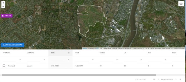
Entering into the application the user is greeted with the Cemetery boundary aganst a color satellite image as background at top, and a Data Input console at bottom.
 The layer list in the maps upper right-hand corner controls the visibility of layers displayed.
Turning on the Image Clarity data has higher resolution at maximum zoom-in scale.
Burial Locator Data Input Console
 This tool conducts a search of burial data. Input criteria filters the selection; Exploring results permits selection of a single record.
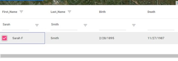
Step 1-Begin by entering the Last Name of the burial to be located, on the space immediately below the Last_Name column title.
Step 2-Enter the First name in it's column.
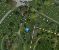
Step 3- Toggle through the selections. Identify the burial by checkmark; The target location appears as a blue pointer.
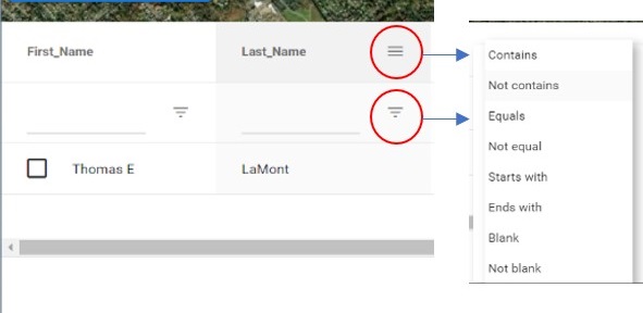
Burial Locator Filters
Both layered-line icons as circled reveal the filtering options.
Contains is the default, however, when enteing the last name, Equals may be a preferred choice.
Statistics appear at the bottom right of the input screen. Tapping directional carrots illustrated below ( < > ) allows inspection of the filter results one record at a time.
Filtering of Birth and Death dates where displayed may further narrow the record search.

In the upper left corner of the map are a series of control icons. A mouseover of any icon responds with its purpose.

Zoom in/Zoom out. Alternatively, the scroll on the desktops mouse will also perform this function. Dragging with the mouse performs the Pan function.


Where Am I? Using the GPS features of a smartphone or tablet, your current position will be located. GPS position is indicated by a Blue dot. The surrounding lighter blue circle indicaes the accuracy range of your GPS signal.
Usage Notes:
The burials database contains 100,000 records, including recent burials up to May 2021. It is acknowledged that not all ARC burials are included in this database. Many older burials and burial places require further investigation. Work is continuing to improve these data.A high percentage of records contain a Death date which can assist in record selection, as can the Birth date if this value has been recorded. Both fields can be filtered using the same process employed with the name fields.
If the burial is in a Tier, examination of the selected record may also reveal the grave position, useful to interpret the burial distance from the beginning of the Tier.
The table of contents has been expanded to include 2 different image backgrounds. The source titled “Image Clarity” has higher resolution at maximum zoom scale.
Activating the Where am I tool will highlight your present position and allow navigatioin to the selected Lot or Tier.