
Tracking the Spread of Pandemics with Geographic Information Systems
Contact(s): Catherine Herman (518) 956-8150
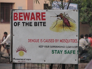 |
One expert at the School of Public Health conference will discuss the clustering of Dengue virus in Thai villages. |
ALBANY, N.Y. (May 5, 2009) -- As public health officials continue to track the path of swine flu around the world, it becomes evident that the technology used for such monitoring -- Geographic Information Systems (GIS) -- is an indispensable tool.
The University at Albany's School of Public Health is hosting a conference May 5-6 on the applications of GIS to international health. Guest speakers will address topics including the clustering of Dengue virus in Thai villages, and tracking the polio virus down the Congo River.
GIS links data and geography digitally in order to make maps. This technology often provides a useful way to reveal spatial and temporal links among data and can help monitor the global spread of a pandemic.
"The swine flu outbreak is a good example of how GIS is used to track and share information," said Assistant Professor of epidemiology and biostatistics Mike Zdeb. "When you click on a world map on a news Web site such as The New York Times and see the clusters of dots of documented cases, you are seeing GIS at work. The sooner public health officials share this information, the more quickly they can respond to an outbreak like swine flu."
This is the fifth year of the conference, which has covered the role of GIS in tracking environmental health problems and the incidence of cancer in the past. It includes internationally known experts on how GIS helps public health officials battle the spread of infectious disease around the world.
"The University at Albany's School of Public Health has developed a reputation for drawing top experts in the field on the issues that matter most in global public health," said Dean Philip C. Nasca.
Ellen K. Cromley, a senior research associate at The Institute for Community Research in Hartford, Conn., and an assistant clinical professor in the Department of Community Medicine, in the University of Connecticut's School of Medicine, is the keynote speaker. In August, she will present the results of research on the role of alcohol in sexual risk behavior among adult males in slum communities in Mumbai, India. At UAlbany, her topic is developing spatial databases for social and behavioral research in communities outside the U.S.
Raoul Kamadjeu, National Center for Immunization and Respiratory Disease, of the Centers for Disease Control and Prevention, gives technical support to nations in Africa and Asia as they fight preventable diseases, including polio. A disturbing pattern has developed in Africa in the past year and a half, with polio being reported in 15 countries in Africa. Kamadjeu will discuss Tracking the Polio Virus down the Congo River: a Case Study on the Use of Google Earth in Public Health Planning and Mapping.
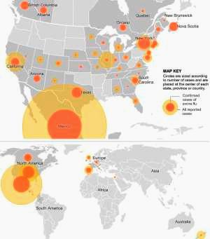 |
Geographic Information Systems (GIS) can be used to show the spread of swine flu. (The New York Times) |
Other speakers include:
� Molly E. Brown, a research scientist from the NASA-Goddard Space Flight Center, on Climate Change and the Famine Early Warning System;
� Jared Aldstadt, of the University at Buffalo's Department of Geography on Spatial and Temporal Clustering of Dengue Virus Transmission in Thai Villages;
� Wayne Myers, professor of Forest Biometrics and co-director of the Office of Remote Sensing of Earth Resources at Pennsylvania State University's School of Forest Resources on using GIS to cope with complex social/environmental issues;
� Deborah Balk, associate professor of Baruch College/CUNY School of Public Affairs, on how a spatial view of urbanization can be used to understand the impact on health of issues like climate change and poverty.
For more information, go to http://www.ualbanycphp.org/
![]() For more news, subscribe to UAlbany's RSS headline feeds
For more news, subscribe to UAlbany's RSS headline feeds
Educationally and culturally, the University at Albany-SUNY puts "The World Within Reach" for its 18,000 students. An internationally recognized research university with 58 undergraduate majors and 128 graduate degree programs, UAlbany is a leader among all New York State colleges and universities in such diverse fields as public policy, nanotechnology and criminal justice. With a curriculum enhanced by 300 study-abroad opportunities, UAlbany launches great careers. For more information about this globally ranked University, visit www.albany.edu. For UAlbany's extensive roster of faculty experts, visit www.albany.edu/news/experts.shtml.
