By Lisa James Goldsberry
s the Capital District transforms itself into a center for innovative businesses, high-technology firms are realizing the value of the Albany area as a resource. The University at Albany is leading the way in providing the necessary talent for these companies and agencies through its many departments and programs, including Geographic Information Systems (GIS).
A GIS is a computer-based system for handling and analyzing spatially structured information, with facilities for processing, retrieval and display (including maps, imagery and other graphics). The disciplines of automated cartography, remote sensing and computer graphics are closely linked in the study of GIS. UAlbany�s GIS program provides students in various disciplines, and continuing students who work for government and private agencies, with professional and technical training in GIS and in associated techniques of spatial analysis.
The GIS certificate has been very popular with state office workers from the departments of Transportation, Health and Education, as well as from social service agencies. Non profits, such as the Environmental Clearinghouse and the Audubon Society, have also shown interest in the program.
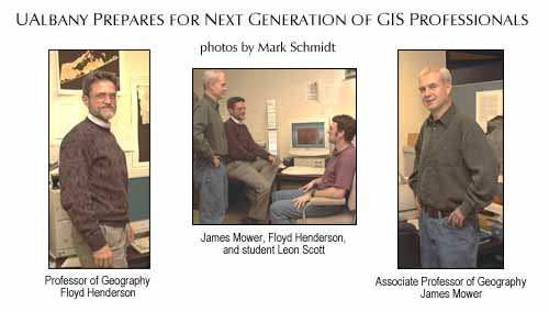
Students already enrolled in the graduate geography program have also found the certificate beneficial. �They want to have this other piece of paper that essentially tells employers that they really know geographic information systems and they are prepared for work or management positions in this area,� said James Mower, associate professor of geography and planning and co-director of the GIS and Remote Sensing Laboratory. Mower added that the program teaches everything from how to buy, set up, and use GIS equipment to how to get a program off the ground.
�We have more job openings for our graduates than we can fill right now,� Mower said. �This is a great area for them because of the GIS firms in the Capital District as well as all the state agencies here with both a need and a budget for GIS employees.�
Floyd Henderson, professor of geography and planning and co-director of the GIS and Remote Sensing Laboratory, added, �Their tickets are open. The experience they are able to bring to a position is well-received and we now have our former students teaching the new generation of GIS students.�
Graduates of the program have gone into a variety of fields, including public service. Many have joined software companies such as MapInfo, which is involved in everything from GIS design work to data development and customer support. Founded in 1986, MapInfo is the market leader in location-based business intelligence, offering consulting services and support for businesses to better find, serve, and develop their own customers.
Others take a slightly different path. Former students Patrick Grady and Dingqiang Zhong, MRP �94, founded Millennium International Technologies, Inc., (MIT) in upstate New York. They met while students at the University. In addition to providing high quality consulting work, their major products, called EZ-Plot and EZ-Map, are very popular.
Timothy Daly (BA �95, MA �99), works as a geographic information systems programmer/analyst at the New York State Department of Environmental Conservation in Albany. �The University�s program had a strong focus on the fundamentals and concepts of GIS and image analysis, both of which are frequently relevant to my current position,� Daly said.
Robert Chasan, who is originally from New City, N.Y., earned a master�s degree in geography with a concentration in GIS in 1998. Chasan is the geographer/urban planning specialist for the City of Scottsdale, Ariz. As part of his position, he provides a wide variety of services, including making maps for city departments, administering aerial photo contracts and airborne multi-spectral remote sensing image processing, and assisting city staffers in their desktop GIS projects. �My remote sensing research assistantship in Professor Henderson�s lab gave me an unparalleled opportunity to do remote sensing research on an intensive, professional level,� Chasan said.
There are approximately 40 students in the GIS certificate program. They have worked as summer interns all over the country, at organizations such as Environmental Systems Research Institute in California and the New York State Department of State Coastal Management Program.
Over the years, several students have worked with the Coastal Management program to create a land cover map, using satellite imagery, for all of Long Island. They also helped the program develop a change analysis of the land cover of Long Island over a 10-year period, and created a spatial model using the imagery incorporating soil and elevation information to generate a non-point-source water pollution model. This allows interested parties to go to this model and find out about water quality and wetland management. Therefore, if someone wanted to develop a parcel, he or she could click on an area and see what effect changing the parcel from agricultural land to a shopping center would have on water quality. Currently, some of UAlbany�s interns are expanding on this model to make it more detailed and complex by increasing the detail of land cover, and looking at aspects such as potential fertilizer use.
Because the Long Island shore land is constantly changing, other students, using maps first developed in the 1880s, are working to develop a chronology to digitize what is happening to the shore over time and how it has changed.
Another student GIS project involves the New York Rural Water Association, which represents some of the smaller communities. Through this project students map the watershed and create the same type of digitized map of changes in geology, soil, census tracks, zoning, and current land cover. Leon Scott, a graduate student from Whitehall, N.Y., works as an intern for the association. �We help them in mapping so they can do analyses of where to develop,� Scott said. �I decided on the GIS program here at the University at Albany because it encompasses my interests in both environmental issues and working with computers,� he said.
Some UAlbany interns are working with the Department of Environmental Conservation and its many sub-divisions (public lands, fish, and wildlife) to address a variety of issues. One just completed a map of forest trails in New York State, for use in brochures of every district. A few years ago, students helped to convert topographic maps showing elevations in New York State to a digital format. According to Mower, New York is one of only a few states that make this information available to the public online.
�We are trying to get our students ready not only for the current generation of mapping but for the next generation, which will probably be more Internet-based,� Mower said. �We still emphasize good cartography skills, but we also try to get people to think about GIS not always from a consumer�s point of view but also from a producer�s point of view.�
According to Mower, one of the up-and-coming fields in the GIS arena is microfarming, which uses remote sensing data to determine aspects such as when and where to apply fertilizer. Ray Bromley, chair of the Department of Geography and Planning, says another potential growth area is target marketing. �Many marketing firms are paying big salaries to GIS people to tell them about things such as demographics, business expansion, distribution routes, sales territories, and buying patterns,� Bromley said.